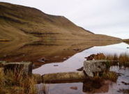
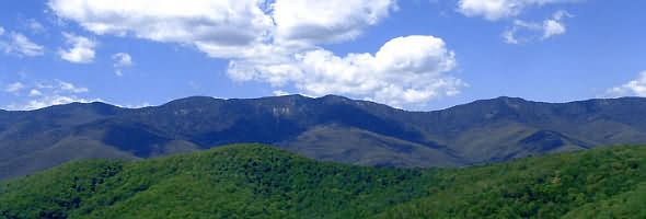
Designated a national park in 1957. The Brecon Beacons National Park is situated in mid-Wales. It contains some of the most spectacular and distinctive upland formations in southern Britain, The park occupies 519 sq miles (1,344 sq km) of mountains, moors, forests, pastureland, lakes, and the broad Usk valley. The easternmost highlands in the park, lying between Abergavenny and Hay-on-Wye, are the Black Mountains (old red sandstone) - highest point Waun Fach (2,660 ft [811 m]). Centrally located within the park, south of Brecon, are the Brecon Beacons (old red sandstone) including Pen-y-Fan (2,906 ft [886 m]), the highest peak in the park. To the west lies the Black Mountain (chiefly millstone grit). The park offers a considerable variety of scenery and recreational opportunities, including hill walking, caving, pony trekking, sailing, and angling. This amazing landscape has now been officially recognised as one of the most important geological landscapes in Europe. In October 2005, the Brecon Beacons National Park Authority was awarded membership of the highly prestigious European Geopark Network and given UNESCO Global Geopark recognition for the Fforest Fawr Geopark.
The Brecon Beacons National Park ranges from Llandeilo in the west to Hay on Wye in the east which contain a wide variety of spectacular scenery, with mountains, waterfalls, lakes and caves. The Brecon Beacons is home to many species of bird life and wild plants. In the Brecon Beacons National Park, you will find small towns, quaint villages and tiny hamlets sprinkled across the area. Ruined Welsh castles, Celtic standing stones and relics dating from the Neolithic and Bronze Age are to be found, some inscribed stones date from the 5th and 6th centuries.
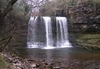
Four mountain ranges are contained within the national park, each with its own distinct personality. In the west of the Brecon Beacons is the remote Black Mountain. An area of wild grandeur, sheer limestone cliffs and impressive views. Forest Fawr (the name is derived from ancient times as a hunting ground), an area beloved by walkers, with lush countryside and wonderful waterfalls.
Abergavenny is a small market town in Monmouthshire (formerly Gwent) in south east Wales, at the confluence of the Rivers Gavenny and Usk and on the edge of the Brecon Beacons National Park. The strategic nature of this site, guarding a main valley corridor between the Black Mountains and the Brecon Beacons into South Wales, was recognized by the Romans, who built the fortress of Gobannium, and by the Normans, who built an 11th-century castle. The town that grew under the castle's protection was attacked at various times over the next 500 years. Abergavenny held important cattle and horse fairs in the 18th and 19th centuries and developed some flannel making; it never participated in the industrial growth of the coalfield towns to the west. Now a service centre and attractive holiday resort, it has also become a residential base for commuters employed in South Wales and nearby England. Abergavenny can be used as a base for many delightful walks in the Brecon Beacons National Park.
Sugar Loaf Mountain
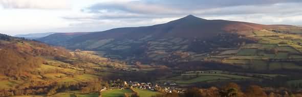
, usually called simply the Sugar Loaf (Welsh: Mynydd Pen-Y-Fal or Y Fâl), is a mountain situated north-west of Abergavenny in Monmouthshire, Wales. One of the Black Mountains, its height is 596 metres. A Sugar Loaf foothill, Y Graig, was discovered in the 1990s to be the site of prehistoric flint tools dating from the Mesolithic, Neolithic and Bronze Age.
The Sugar Loaf is very popular with walkers. A vineyard, producing Sugar Loaf wines, is situated at Dunmar Farm at the foot of the mountain. East of the Beacons is the conical summit of Sugar Loaf mountain, overlooking the market town of Abergavenny and commanding stunning panoramic views across the Usk valley. Nearby, the Skirrid Fawr, known locally as the holy mountain, offers both woodland and upland walks.
The Black Mountains
are a group of hills in south-eastern Wales, and a small part of Herefordshire, England. They are the easternmost of the three groups of hills that are covered by the Brecon Beacons National Park, and are frequently confused with the westernmost, which are collectively called the Black Mountain. (To confuse matters further, there is a peak in the Black Mountains called Black Mountain.) They may be roughly defined as those hills north of Abergavenny, south of Hay-on-Wye, east of the A479 road (the Rhiangoll valley) and west of, or on, the English border. The Offa's Dyke long-distance footpath runs along the border. The area is popular with hillwalkers and pony trekkers. There are few villages in this area and one youth hostel, at Capel-y-ffin. The Skirrid Inn also has a wider reputation, being claimed as the oldest Public House in Wales. Antiquities include Llanthony Priory, Tretower castle and court, the Iron Age hill fort Crug Hywel, and Castell Dinas, an 11th- to 13th-century castle.
The highest mountain in the group is Waun Fach (811 m); other mountains include the Sugar Loaf, Ysgyryd Fawr, Mynydd Troed, Graig Syfyrddin, Allt yr Esgair, Myarth, Mynydd Llangorse, Bryn Arw, and Black Mountain. Ysgyryd Fawr is also known as the Skirrid, Skyrrid or 'Holy Mountain'.
The Black Mountain
is a mountain in the Black Mountains (not to be confused with the Black Mountain range of hills). It is the only hill to fall exactly on the Welsh-English border, straddling Powys and Herefordshire. Offa's Dyke long distance footpath passes along the ridge, more or less from south to north (or vice versa), while a steeper path leads to the summit from near the youth hostel in the Vale of Ewyas to the west.
It is the highest ground in England south of the Yorkshire Dales, even though higher neighbours are very close by in Wales.
Mountain rescue in Wales is provided by seven groups, with assistance from local Police, and in serious situations an RAF helicopter from RAF Valley. These are:
BMRT - Brecon Mountain Rescue Team
SARDA - Search and Rescue Dog Association
C/Beacons - Central Beacons
W/Beacons - Western Beacons
LMRT - Longtown Mountain Rescue Team
NEWSAR - North East Wales Search and Rescue
SARA - Severn Area Rescue Association
Most are staffed by local volunteers and funded primarily by donations. Their work is not restricted to mountain and wilderness rescue; often teams are utilised by the local police to search for missing or vulnerable persons in the community.